
Murray Hay 1931-2015
Piste Maps -
We are fortunate to exhibit for sale unique and original piste maps by Murray Hay (1931-2015). A well known Calgary artist, best known for painting ski areas (piste maps) from 1976 to the early 2000’s, who left behind a unique legacy. His work helped thousands of skiers navigate many beautiful ski areas, including the featured Lake Louise, Fernie, Kimberley, and Azu Powder King.
Azu Powder King, BC (rare, unique), 1980, piste map, with separate overlay, acrylic on foam board; 36.5 x 51 inches (93 x 129.5 cm); signed l.l. (Murray Hay); Description: panorama view, mountain ski resort piste map with overlay showing ski runs of Azu – Powder King Ski Resort, BC (Highway 97, near Mackenzie, BC), $10,200 Cdn.

Azu Powder King, BC (rare, unique), 1980, piste map, showing overlay.

Fernie, BC, c. 1980 (with revisions to 1990), piste map without overlay, acrylic on foam board; 34 x 46 inches (86.5 x 117 cm), signed l.l. (Murray Hay), Description: panorama view, mountain ski resort piste map of Fernie Ski Resort, BC., framed, $9300 Cdn.

Fernie, BC, c. 1980 (with revisions to 1990), piste map without overlay.

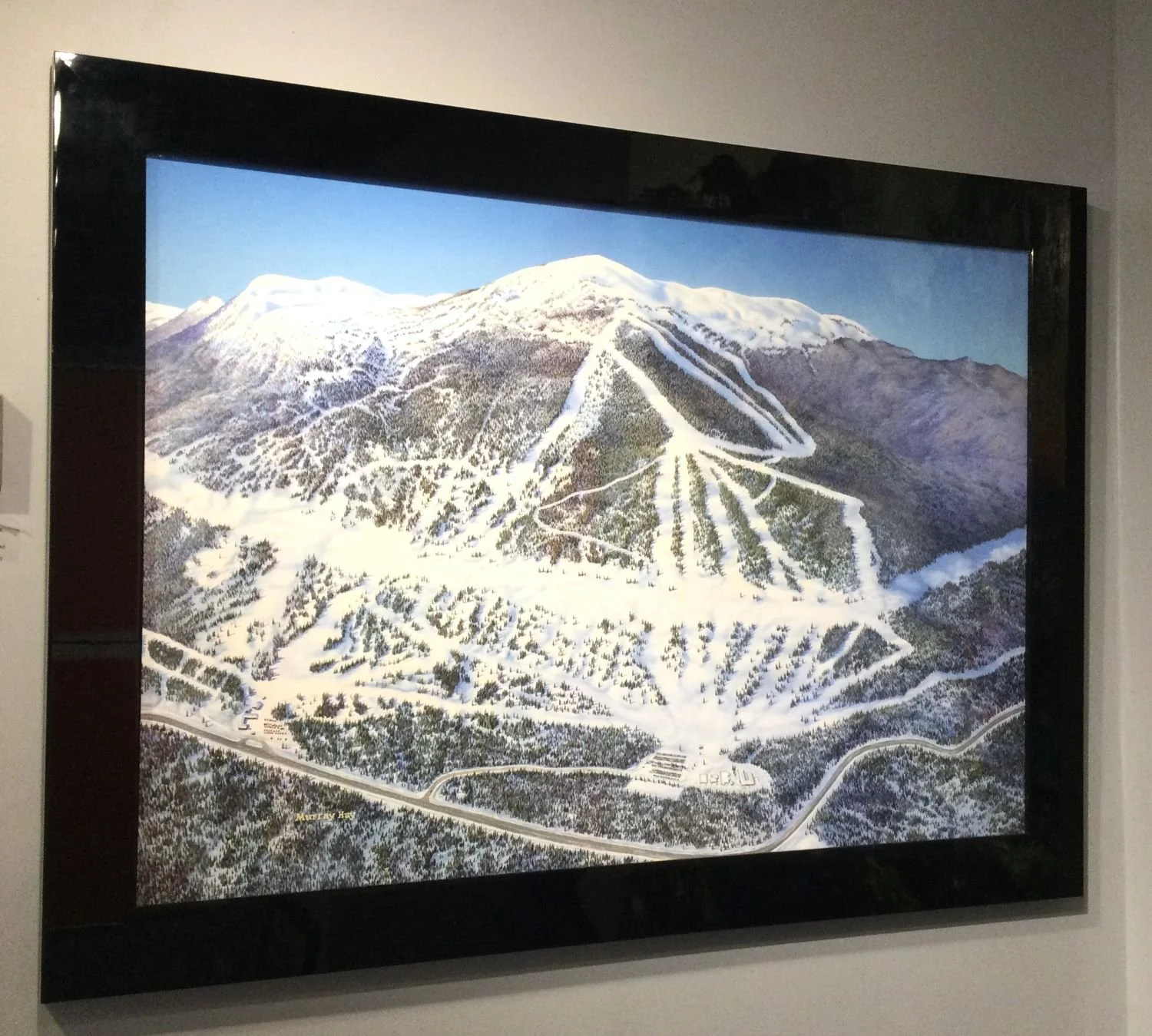
Kimberley, BC; c. 1982 (with revisions to 1990), piste map without overlay, acrylic on foam board; 29 x 45 inches (74 x 114.5 cm); signed lower centre left (Murray Hay); Description: panorama view, mountain ski resort piste map of Kimberly Ski Resort, BC., framed, $8600 Cdn.

Kimberley, BC; c. 1982 (with revisions to 1990), piste map without overlay.

signature

Lake Louise Ski Race, c.1980s, piste map without overlay, acrylic on foam board; 18 x 27.5 inches (46 x 70 cm), signed l.l. (Murray Hay), Description: panorama view, mountain ski race route at Lake Louise Ski Resort, Banff, Alberta, sold.
““He was able to create a marriage of cartography and art that is used for business, tourism, safety, and education—while also being remarkably beautiful paintings.””
Piste Maps.
Definitions.
Piste - French term - a groomed course or run for skiing.
Piste map - ski map showing locations of slopes and trails for downhill skiing, as well as areas that are ‘off-piste’ (out of bounds).
Literature References and Illustration:
Knowles, Lori. “The Art of the Unexpected.” Ski History Magazine. November-December 2017, 11-2.
Maxwell-Alves, Courtney. “What Is a Ski Map?”: Murray Hay and the Ski Maps of the Canadian Rockies.” Nov 24, 2021 (Whyte Museum of the Canadian Rockies website: https://www.whyte.org/post/murray-hay-ski-maps-canadian-rockies).
Morrow, Pat. Beyond Everest, Quest for the Seven Summits. Camden House, c. 1986.
Murray Hay Ski Maps-Facebook: https://www.facebook.com/Murrayhayskimaps/
Tait, Alex. “Mountain Ski Maps of North America, A Preliminary Survey and Analysis of Style.” 6th ICA Mountain Cartography Workshop, Mountain Mapping and Visualisation, 2008.
Whyte Museum of the Canadian Rockies Archives – Murray Hay fonds.
Skiing has long been a major attraction and an integral part of the human history and culture of the Canadian Rocky Mountains. As the ski industry developed, so too did the need for detailed trail maps—along with artists to create them. In 1976, self-taught artist Murray Hay was approached by Charlie Locke and Sir Rodney Touche with a request to paint a ski map for the Lake Louise ski hill. Having never skied and knowing little about mountains, his initial reaction was: “What is a ski map?!” Despite his uncertainty, he took on the challenge—a decision that would ultimately reshape the course of his career.
Born on October 1, 1931, in Regina, Saskatchewan, Murray Hay left home at 16 to travel, eventually spending a year in Melbourne, Australia. There, he painted and sold greeting cards while embracing the beach lifestyle. Upon returning to Canada, he settled in Calgary around 1960, where he lived with his wife and two daughters until his passing on October 27, 2015.
A master of ski map artistry, Murray Hay worked from the basement studio of his Calgary home. After creating his first ski map for Lake Louise, word of his talent quickly spread. He was soon commissioned to paint maps for Sunshine Village and Mount Norquay, and demand for his work grew from there. Hay’s expertise was sought by ski resorts across Canada, North America, and internationally. His skills also extended beyond ski maps—he was commissioned to create maps for Olympic bids, including Calgary 1988 and Alyeska 1992, as well as tourism maps for brochures and magazines such as Equinox, Reader’s Digest, and city guides like Keys to Calgary.
Hay’s artistic process is fascinating. For his early ski maps of the “Big Three” in the mid-1970s, he initially relied on resource materials and reference photos provided by the ski hills. However, unsatisfied with the results, he began taking his own aerial photographs—often from a small plane or helicopter. Wearing a harness, he would shoot numerous photos from an open door, later laying them out and taping them together until he achieved the ideal perspective and angle the ski hill required. Over the following weeks, Hay sketched his first draft on tracing paper, tacking it onto a board. He then applied a grid to transfer the drawing onto the final surface before beginning the painting process. Throughout, he regularly visited the ski hill to ensure accuracy and alignment with his contract. Each painting took approximately three to four months to complete. Once finished, Hay added overlays to incorporate trail lines, names, legends, and any other necessary details.
Upon completing a project, Hay would deliver the finished painting to the ski hill, which would then photograph it for reproduction in brochures, pocket trail maps, and other materials. Once the overlays were removed, the original artwork was often displayed in the ski hill’s main office or lodge, where it typically remained. As ski trails evolved and new developments were added, Hay painted updated maps for many resorts. While he worked with numerous ski hills, he had personal favorites—Lake Louise and Sunshine among them. His passion for painting mountains eventually led him to take up skiing himself. Hay often negotiated his contracts creatively, sometimes lowering the price of a painting or adjusting terms to include a ski week for himself and his daughters, Allison and Lynda.
Mountains—especially the Canadian Rockies—became Murray Hay’s comfort zone and creative sanctuary. His first ski hill commission in 1976 not only changed the trajectory of his career but also established him as a trailblazer in ski map creation across North America. Working primarily with acrylic paints, Hay always began with the sky, rarely sat while painting, and was known for his sharp sense of humor. When the meticulous detail of his work became tedious, he entertained himself by adding subtle, almost imperceptible details—like tiny wipeouts or car crashes—known only to him.
As his daughter Allison describes, “He was able to create a marriage of cartography and art that is used for business, tourism, safety, and education—while also being remarkably beautiful paintings.” (text courtesy of Whyte Museum of the Canadian Rockies).
Exhibitions:
Piste Maps - during the 2021 Banff Centre Mountain Film & Book Festival (October 30 to November 7), Willock & Sax Gallery.